I had a day off in Mahendranagar, not unrelated to the previous night's drinking to celebrate Nepali New Year. When I did leave, I was up earlier than I'd planned as my hotel was opposite the bus stand, and for some reason the drivers sit for hours blaring their horns while their buses fill with passengers. This is not conducive to lying in.
I had planned to take a side road up the valley towards my destination. Well, I say destination. It was just that on my ridiculously large-scale map (1:1,000,000, which was the only map I could find) there are roads marked going north up the valley, which I thought I'd follow, hoping to see icy peaks and get some climbing into my legs. I tend to plan things on the go, which is just as well as I haven't been able to find any reports on the web of other touring cyclists coming this way.
I must have missed that side road, or more likely it was such an unprepossessing dirt road that I dismissed it. I did see the other end of it further up the valley, and I was relieved that I hadn't taken it, as it was a muddy track, and given how hilly the main road was, it would have been hell to ride with all the weight on my bike.
Actually, I wasn't even sure that I was on the main highway. There was so little traffic, especially compared to congested India - I blame it on the New Year festivities. However, locals assured me that I was going the right way, and it was an enjoyable plod through Sukla Phanta Wildlife Reserve, the road lined with trees and rolling pleasantly. Good surface, too.
Food for the day was mainly cream doughnuts, as I still have hardly any appetite and struggle to keep down anything richer than porridge. Sadly, the doughnuts were to become victims of ants later that day when I camped up.
There were no roadsigns and all of the kilometre posts were in Nepali, but I did find the turning I wanted, up to Dadeldhura. Locals were astonished when I said I was going to Dadeldhura - I think hardly any tourists come here, especially by bicycle. Western Nepal is the poorest region of an already-poor country. With this in mind, I stocked up on plenty of water and food and beer in Atariya.
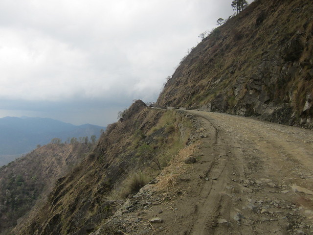
This was where the road started to go up into the Shiwaliks, the lowest and newest range of the Himalayas. I was reminded of a couple of things on this climb - firstly, you do need food. I was stopping regularly on the climb (which was a biggie - the road ascends from about 200 metres above sea level on the plains to 2000 metres, and these are only the foothills), to let my legs rest and take a few photos of the impressive views. The escarpment rises almost directly out of the plains, and the contrast in altitudes made for some magnificent drop-offs.
Secondly, distance on the map doesn't necessarily reflect distance on the road. After crossing a rickety bridge over the Mohana River, the road switchbacked up the hillside, and instead of the 40 miles to Dadeldhura from Atariya which the map suggested, it was about 90 miles. No map at a usable scale would be able to show all these switchbacks.

I stopped early to camp at one of the few flat spots by the road and lazed about for a few hours until I pitched my tent and cooked my cordon bleu of noodles with Bovril. A few curious locals came past, and insisted on looking at my maps. It had taken me ages to fold the things at the right page, and within seconds they managed to mangle them out of kilter. I'm not sure they knew what they were looking at, as one girl spent ages looking at northern Tibet on the even-more-ridiculously large scale map I carry, which I've only kept as it has relief and spot heights on it, so I can see what I'm getting into.
Later, a few more wandered up, and one lad spoke a bit of English, but that didn't make conversation very much easier. Among other things he asked "what is your God?" and rather than trying to explain atheism to him (which is difficult enough with people who have a good grasp of English - most people subscribe to some sort of faith in Nepal and India), I told him I was a Christian.
Hypocrisy never pays. He pulled out a cross to show that he was a Christian too, and the next morning he came up at 6.30 am to shout at me: "Wake up, uncle! Praise the Lord!"
"Fuck off," I shouted back. I'm never at my best in the mornings and it was still raining. They did scarper, and I had another hour's sleep.
My sleep had been disturbed enough already; since a rat had chewed into my luggage and eaten a hole in my sleeping mat in a nasty hotel in Madhya Pradesh, I have tried to repair it, but it still keeps going down. I was awoken by a huge stone digging into my side at 1.30 am, and disconsolately I straddled the mat to pump a bit more air into it. At the same time a huge storm was clashing over the mountains, but in the next valley. I stepped outside my tent for a bit to watch the show.
More climbing the next day. I reckon it was 25 miles uphill from the plains to the top of the escarpment. My worries about buying provisions were completely unfounded. Villages were quite regular, even the smaller ones having little shops where you can buy biscuits and peanut brittle and instant noodles, and the larger ones have roadside dhabas (also selling bottled water and beer) where the meal is usually an all-you-can-eat platter of soup, rice and fried potatoes. I could only keep down the potatoes, and rather than leave my meal and appear to be a wasteful westerner I took it away with me in a plastic bag and fed it to some monkeys up the road.
I nearly turned back near the top of the climb, as the road turned to shite. At some point the monsoon rains had washed away the surface and all that was left was mud, gravel and huge rocks embedded in the mud. As this was also the steepest point of the route, I had to push my bike. Thankfully good tarmac returned after about 200 yards.
I'm really pleased I carried on. It wasn't just the road surface which was making me nervous, it was also the isolation. The New Year celebrations, and it being a Sunday, were obviously keeping people off the roads, but after congested India where houses and people lined the roadsides and I couldn't so much as stop without a crowd forming, it was unnerving to be on my own again.
Not to mention the storm that was brewing. While I was riding along the rim of the valley, I heard a few rumbles which seemed to come from different directions, so that I wasn't sure if I was riding towards the storm, or away from it. I should have known.
Over the top of the hill, and I finally lost the views of the plains as I descended into a green valley of pines and mist. The road was still greasy from rain which had obviously fallen recently. I took it easy on the switchbacks, and stopped at the next village for chai with a local elder, whom I pestered for advice about the next stretch. We didn't share a language, but I got the message across by making the universal sign for hilliness: hold your hand at a 45 degree angle and stab up with your fingers. His reply was that it's about twenty kilometres to Budar, where there was a guest house, and the road goes along the valley rather than up to the peaks.
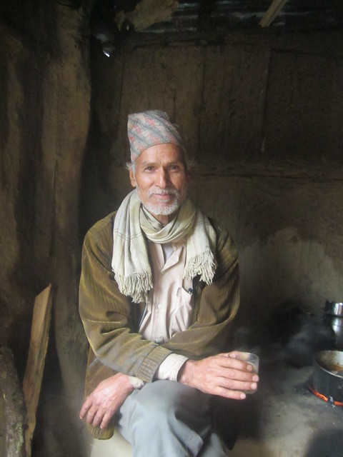
I thanked him for the chai and left, just as the storm hit. I took shelter in another dhaba a hundred yards down the hill, where I was in good company as not only did a few swallows follow me in and perch on the trailing electrical wires, but a half dozen armed police were sat around eating their dinner. The torrential rain wasn't slackening, so I grabbed a beer and sat with the coppers. Beer and alcohol are available nearly everywhere. I don't think the half-drunk bottle of vodka on the table belonged to the coppers, and they didn't offer me any, though they were kind enough to share their dinner of...meat. They didn't understand what I meant when I asked what kind of meat it was - they just said it was meat. I did ask what kind of animal it came from, but the reply was "yes, animal." I suspect it was goat, as goats are the commonest livestock around here, but I've never had goat before and the meat was too well spiced for much flavour to linger. Texture-wise, it was more like pork scratchings than anything else.
I asked the lads the same question - how hilly is the road from here? I asked loads of questions about facilities and road conditions of the locals, as I didn't have any other information to go on, and I received lots of useful, reassuring information about the conditions and the traffic and the number of villages. One copper told me that the road to Budar was very hilly, at which point I wondered if I'd misunderstood the old man, and if having that beer had been a bad idea.
I reckon the old man had it about right. The road wound between low valleys, occasionally climbing a bit, but nothing to compare with that big climb away from the plains. The rain passed over and it was a wonderful beer-fuelled meander through the pine forests and lush valleys, with a rainbow far below me.
I checked into the guest house at Budar, planning to fix my mat, but I only had the energy to read a bit and wash my clothes. I couldn't even face proper food - I ate a few doughnuts and some crisps.

The rain and clouds cleared during the night - it was a bright, crisp morning. I'm pleased to be away from the sultry plains and into the mountains, where the air is rare. I'm even enjoying the rain, as until the last week I hadn't been rained on for 5,000 miles. No doubt the novelty will wear off soon.
Breakfast was more doughnuts, and an omelette from the guest house. I asked for a plain omelette, as they usually put far too many onions in for my taste. The correct amount of onion, by the way, is none.
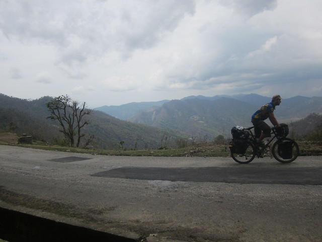
It was another huge climb out of Budar. I was glad of that omelette. But with the clear air and high cloud base, I could see for miles. Looking back, there were hills and hills, which I'd already crossed. I was surprised to see how many lines of hills lay behind me. I was travelling slowly and I hadn't realised how much terrain I'd covered. And still no glacier-clad crags cresting the northern sky.
Again, I took plenty of stops, to watch the buzzards circling above the trees, and to spot shapes in the fluffy cumulous clouds which started to develop in mid-afternoon. Is there anything fluffier than a cloud?
Apart from a couple of brief downhills, it was an 18-mile climb to around 2500 metres from Budar. A couple of Nepali kids ran alongside me for a bit, and they probably could have overtaken me at times. I had a stop at Gaira Bazaar, about 12 miles from Budar, where I tried and failed to negotiate a plate of potatoes/alu.
I had to go carefully on the descent - the road surface was OK, but there were enough bumps and lumps and washouts to make me wary of letting it go. It was around this point that I realised I was making a one-way trip, and I could have left half my luggage at the guest house in Budar to collect on the way back. I'm unlikely to need my maps of India or the National Geographic Titanic Anniversary Edition on the road to Darchula.
The landscape since the plains had been typical of the Shiwaliks - broad, flat-topped hills covered in verdant forests, above well-kept farmland. The hillsides have fields stepped into them, and mountain goats roam while the herders doze in the sun. Locals walked the road from village to village carrying huge bundles of firewood or water - it was usually the women doing most of the carrying, while the men walked alongside and chatted.
But at the top of the climb the landscape started to change. I had my first view of the middle Himalayas, where bare slopes thrust above the treeline, and above those, in the hazy distance, a glimpse of crags and glaciers. The Upper Himalayas. I had a burst of joy at seeing them, finally. The view was occluded by trees and distance, but they were there, and I was getting closer.
I was so taken in that I took the wrong turning at a fork in the road, and it was only when I'd screamed down a steep descent for two miles that I looked at the road ahead and thought "Dadeldhura's not that low!" I checked with Google Maps on my phone, but that didn't know where Dadeldhura was, and I asked a passing local, and he confirmed that yup, it's back up that way. My only consolations were that I'd stopped before going all the way down, and that this alternative route did give me some damn good views. 45 minutes later, I winched myself back to where the road had forked. In my defence, the sign at the turn did say "Dadeldhura," but it actually meant that Dadeldhura was in the other direction. Obviously.
I found a cheap guest house in Dadeldhura and again, I was too tired to fix my mat. I ordered veg fried rice, but even that was too rich for my stomach. I decided to have a day off to look around the town, re-organise my kit so that I can travel light to Darchula, and finally, hopefully, fix my mat. I didn't get as much sleep as I'd hoped for - the dawn chorus of sniff-hawk-spit from adjoining rooms kiboshed that, as did the 6 am wake-up for yak butter tea.
I have been the main attraction in town as I don't think there are any other western tourists here at the moment, but Dadeldhura is well set-up to cater for visitors. It has a few hotels and ATMs and lots of little shops. I had a wander around and topped up my phone credit, but the level of attention was far less than in India: mainly, friendly people waving and saying Namastes. I didn't stay out for long as there isn't anything to see, and the alleged cyber cafe didn't materialise, so no photos yet.
I have (I think) fixed my mat, and I've set aside three bags to leave here for a few days while I travel up and up, to Darchula on the border with India. It feels a little bit like cheating, but I'll be able to ride faster, and reports of the road conditions suggest that the surface gets rocky, gravelly and muddy. I don't want to place that sort of stress on my bike when I don't need to. Of course, I'm hoping to have close views of the Api range and the high, high Himalayas. Why else did I come?
A few numbers:
14/04/2012, Day 217: from Mahendranagar, H01, Altaria, H14, campsite - 37.53 miles, 3:44:26, 18.4 mph max
15/04/2012, Day 218: from campsite, H14, Chhatiwan, Budar - 31.23 miles, 4:24:48, 31.4 mph max
16/04/2012, Day 219: from Budar, Gaira Bazaar, Dadeldhura - 39.09 miles, 5:15:03, 36.3 mph max, 8057.0 miles in total
I had planned to take a side road up the valley towards my destination. Well, I say destination. It was just that on my ridiculously large-scale map (1:1,000,000, which was the only map I could find) there are roads marked going north up the valley, which I thought I'd follow, hoping to see icy peaks and get some climbing into my legs. I tend to plan things on the go, which is just as well as I haven't been able to find any reports on the web of other touring cyclists coming this way.
I must have missed that side road, or more likely it was such an unprepossessing dirt road that I dismissed it. I did see the other end of it further up the valley, and I was relieved that I hadn't taken it, as it was a muddy track, and given how hilly the main road was, it would have been hell to ride with all the weight on my bike.
Actually, I wasn't even sure that I was on the main highway. There was so little traffic, especially compared to congested India - I blame it on the New Year festivities. However, locals assured me that I was going the right way, and it was an enjoyable plod through Sukla Phanta Wildlife Reserve, the road lined with trees and rolling pleasantly. Good surface, too.
Food for the day was mainly cream doughnuts, as I still have hardly any appetite and struggle to keep down anything richer than porridge. Sadly, the doughnuts were to become victims of ants later that day when I camped up.
There were no roadsigns and all of the kilometre posts were in Nepali, but I did find the turning I wanted, up to Dadeldhura. Locals were astonished when I said I was going to Dadeldhura - I think hardly any tourists come here, especially by bicycle. Western Nepal is the poorest region of an already-poor country. With this in mind, I stocked up on plenty of water and food and beer in Atariya.
This was where the road started to go up into the Shiwaliks, the lowest and newest range of the Himalayas. I was reminded of a couple of things on this climb - firstly, you do need food. I was stopping regularly on the climb (which was a biggie - the road ascends from about 200 metres above sea level on the plains to 2000 metres, and these are only the foothills), to let my legs rest and take a few photos of the impressive views. The escarpment rises almost directly out of the plains, and the contrast in altitudes made for some magnificent drop-offs.
Secondly, distance on the map doesn't necessarily reflect distance on the road. After crossing a rickety bridge over the Mohana River, the road switchbacked up the hillside, and instead of the 40 miles to Dadeldhura from Atariya which the map suggested, it was about 90 miles. No map at a usable scale would be able to show all these switchbacks.
I stopped early to camp at one of the few flat spots by the road and lazed about for a few hours until I pitched my tent and cooked my cordon bleu of noodles with Bovril. A few curious locals came past, and insisted on looking at my maps. It had taken me ages to fold the things at the right page, and within seconds they managed to mangle them out of kilter. I'm not sure they knew what they were looking at, as one girl spent ages looking at northern Tibet on the even-more-ridiculously large scale map I carry, which I've only kept as it has relief and spot heights on it, so I can see what I'm getting into.
Later, a few more wandered up, and one lad spoke a bit of English, but that didn't make conversation very much easier. Among other things he asked "what is your God?" and rather than trying to explain atheism to him (which is difficult enough with people who have a good grasp of English - most people subscribe to some sort of faith in Nepal and India), I told him I was a Christian.
Hypocrisy never pays. He pulled out a cross to show that he was a Christian too, and the next morning he came up at 6.30 am to shout at me: "Wake up, uncle! Praise the Lord!"
"Fuck off," I shouted back. I'm never at my best in the mornings and it was still raining. They did scarper, and I had another hour's sleep.
My sleep had been disturbed enough already; since a rat had chewed into my luggage and eaten a hole in my sleeping mat in a nasty hotel in Madhya Pradesh, I have tried to repair it, but it still keeps going down. I was awoken by a huge stone digging into my side at 1.30 am, and disconsolately I straddled the mat to pump a bit more air into it. At the same time a huge storm was clashing over the mountains, but in the next valley. I stepped outside my tent for a bit to watch the show.
More climbing the next day. I reckon it was 25 miles uphill from the plains to the top of the escarpment. My worries about buying provisions were completely unfounded. Villages were quite regular, even the smaller ones having little shops where you can buy biscuits and peanut brittle and instant noodles, and the larger ones have roadside dhabas (also selling bottled water and beer) where the meal is usually an all-you-can-eat platter of soup, rice and fried potatoes. I could only keep down the potatoes, and rather than leave my meal and appear to be a wasteful westerner I took it away with me in a plastic bag and fed it to some monkeys up the road.
I nearly turned back near the top of the climb, as the road turned to shite. At some point the monsoon rains had washed away the surface and all that was left was mud, gravel and huge rocks embedded in the mud. As this was also the steepest point of the route, I had to push my bike. Thankfully good tarmac returned after about 200 yards.
I'm really pleased I carried on. It wasn't just the road surface which was making me nervous, it was also the isolation. The New Year celebrations, and it being a Sunday, were obviously keeping people off the roads, but after congested India where houses and people lined the roadsides and I couldn't so much as stop without a crowd forming, it was unnerving to be on my own again.
Not to mention the storm that was brewing. While I was riding along the rim of the valley, I heard a few rumbles which seemed to come from different directions, so that I wasn't sure if I was riding towards the storm, or away from it. I should have known.
Over the top of the hill, and I finally lost the views of the plains as I descended into a green valley of pines and mist. The road was still greasy from rain which had obviously fallen recently. I took it easy on the switchbacks, and stopped at the next village for chai with a local elder, whom I pestered for advice about the next stretch. We didn't share a language, but I got the message across by making the universal sign for hilliness: hold your hand at a 45 degree angle and stab up with your fingers. His reply was that it's about twenty kilometres to Budar, where there was a guest house, and the road goes along the valley rather than up to the peaks.
I thanked him for the chai and left, just as the storm hit. I took shelter in another dhaba a hundred yards down the hill, where I was in good company as not only did a few swallows follow me in and perch on the trailing electrical wires, but a half dozen armed police were sat around eating their dinner. The torrential rain wasn't slackening, so I grabbed a beer and sat with the coppers. Beer and alcohol are available nearly everywhere. I don't think the half-drunk bottle of vodka on the table belonged to the coppers, and they didn't offer me any, though they were kind enough to share their dinner of...meat. They didn't understand what I meant when I asked what kind of meat it was - they just said it was meat. I did ask what kind of animal it came from, but the reply was "yes, animal." I suspect it was goat, as goats are the commonest livestock around here, but I've never had goat before and the meat was too well spiced for much flavour to linger. Texture-wise, it was more like pork scratchings than anything else.
I asked the lads the same question - how hilly is the road from here? I asked loads of questions about facilities and road conditions of the locals, as I didn't have any other information to go on, and I received lots of useful, reassuring information about the conditions and the traffic and the number of villages. One copper told me that the road to Budar was very hilly, at which point I wondered if I'd misunderstood the old man, and if having that beer had been a bad idea.
I reckon the old man had it about right. The road wound between low valleys, occasionally climbing a bit, but nothing to compare with that big climb away from the plains. The rain passed over and it was a wonderful beer-fuelled meander through the pine forests and lush valleys, with a rainbow far below me.
I checked into the guest house at Budar, planning to fix my mat, but I only had the energy to read a bit and wash my clothes. I couldn't even face proper food - I ate a few doughnuts and some crisps.
The rain and clouds cleared during the night - it was a bright, crisp morning. I'm pleased to be away from the sultry plains and into the mountains, where the air is rare. I'm even enjoying the rain, as until the last week I hadn't been rained on for 5,000 miles. No doubt the novelty will wear off soon.
Breakfast was more doughnuts, and an omelette from the guest house. I asked for a plain omelette, as they usually put far too many onions in for my taste. The correct amount of onion, by the way, is none.
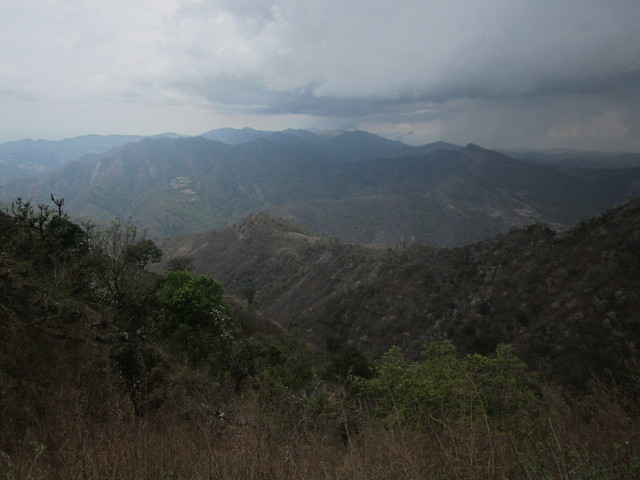
It was another huge climb out of Budar. I was glad of that omelette. But with the clear air and high cloud base, I could see for miles. Looking back, there were hills and hills, which I'd already crossed. I was surprised to see how many lines of hills lay behind me. I was travelling slowly and I hadn't realised how much terrain I'd covered. And still no glacier-clad crags cresting the northern sky.
Again, I took plenty of stops, to watch the buzzards circling above the trees, and to spot shapes in the fluffy cumulous clouds which started to develop in mid-afternoon. Is there anything fluffier than a cloud?
Apart from a couple of brief downhills, it was an 18-mile climb to around 2500 metres from Budar. A couple of Nepali kids ran alongside me for a bit, and they probably could have overtaken me at times. I had a stop at Gaira Bazaar, about 12 miles from Budar, where I tried and failed to negotiate a plate of potatoes/alu.
I had to go carefully on the descent - the road surface was OK, but there were enough bumps and lumps and washouts to make me wary of letting it go. It was around this point that I realised I was making a one-way trip, and I could have left half my luggage at the guest house in Budar to collect on the way back. I'm unlikely to need my maps of India or the National Geographic Titanic Anniversary Edition on the road to Darchula.
The landscape since the plains had been typical of the Shiwaliks - broad, flat-topped hills covered in verdant forests, above well-kept farmland. The hillsides have fields stepped into them, and mountain goats roam while the herders doze in the sun. Locals walked the road from village to village carrying huge bundles of firewood or water - it was usually the women doing most of the carrying, while the men walked alongside and chatted.
But at the top of the climb the landscape started to change. I had my first view of the middle Himalayas, where bare slopes thrust above the treeline, and above those, in the hazy distance, a glimpse of crags and glaciers. The Upper Himalayas. I had a burst of joy at seeing them, finally. The view was occluded by trees and distance, but they were there, and I was getting closer.
I was so taken in that I took the wrong turning at a fork in the road, and it was only when I'd screamed down a steep descent for two miles that I looked at the road ahead and thought "Dadeldhura's not that low!" I checked with Google Maps on my phone, but that didn't know where Dadeldhura was, and I asked a passing local, and he confirmed that yup, it's back up that way. My only consolations were that I'd stopped before going all the way down, and that this alternative route did give me some damn good views. 45 minutes later, I winched myself back to where the road had forked. In my defence, the sign at the turn did say "Dadeldhura," but it actually meant that Dadeldhura was in the other direction. Obviously.
I found a cheap guest house in Dadeldhura and again, I was too tired to fix my mat. I ordered veg fried rice, but even that was too rich for my stomach. I decided to have a day off to look around the town, re-organise my kit so that I can travel light to Darchula, and finally, hopefully, fix my mat. I didn't get as much sleep as I'd hoped for - the dawn chorus of sniff-hawk-spit from adjoining rooms kiboshed that, as did the 6 am wake-up for yak butter tea.
I have been the main attraction in town as I don't think there are any other western tourists here at the moment, but Dadeldhura is well set-up to cater for visitors. It has a few hotels and ATMs and lots of little shops. I had a wander around and topped up my phone credit, but the level of attention was far less than in India: mainly, friendly people waving and saying Namastes. I didn't stay out for long as there isn't anything to see, and the alleged cyber cafe didn't materialise, so no photos yet.
I have (I think) fixed my mat, and I've set aside three bags to leave here for a few days while I travel up and up, to Darchula on the border with India. It feels a little bit like cheating, but I'll be able to ride faster, and reports of the road conditions suggest that the surface gets rocky, gravelly and muddy. I don't want to place that sort of stress on my bike when I don't need to. Of course, I'm hoping to have close views of the Api range and the high, high Himalayas. Why else did I come?
A few numbers:
14/04/2012, Day 217: from Mahendranagar, H01, Altaria, H14, campsite - 37.53 miles, 3:44:26, 18.4 mph max
15/04/2012, Day 218: from campsite, H14, Chhatiwan, Budar - 31.23 miles, 4:24:48, 31.4 mph max
16/04/2012, Day 219: from Budar, Gaira Bazaar, Dadeldhura - 39.09 miles, 5:15:03, 36.3 mph max, 8057.0 miles in total
Can't wait to see the photos Dean. Hope the stomach problems settle down for you.
ReplyDeleteCheers, Tony! I'm feeling better every day. Celebrated with mac n cheez t'other night. I've lost plenty of weight though...
DeleteI'm going to have to wake you up at 6:30 to talk to you about Jesus at some point. The only problem with this is that I'm unlikely to be up at 6:30 myself!
ReplyDeleteThat's OK, Greg. I can tell you to fuck off at a time of day of your choosing.
ReplyDeleteWhich would make you more grumpy, the tasteless evangelism or the obscene hour?
ReplyDeleteJust be yourself, Greg.
Delete