Over-reachers and dreamers. We'd still be living in the trees without people who dared to do more. Of course, reaching too far can also lead to you falling flat on your face.
I'd read about people cycling the Annapurna Circuit, and I fancied giving it a try myself, on the same bike with which I'd ridden to Nepal. I knew that the trail would be very rough and rocky in places and I expected that I'd have to carry my bike for about a quarter of the time.
I made minimal changes to the bike. I took off my clipless pedals, fitted some flat pedals and bought some walking shoes.
I could have bought some knobbly tyres, or taken off my mudguards and racks to save weight. I could also have bought a big rucksack to let me carry my kit on my back and fangled a way of strapping my bike to it for the portage sections. I did none of these things.
I suppose the reactions of other people who'd trekked the route should have given me a hint. Non-cyclists were very enthusiastic and said I'd be fine apart from a few places, including the highest and toughest day where I'd have to carry the bike from Thorong Phedi at 4450 metres ASL to Thorong La itself, at 5416 metres ASL. They also told me there was a road a lot of the way round. Cyclists, on the other hand, tended to wince and say things like "travel as light as you can" or, less reassuringly, "I wouldn't".
In the end, my circuit involved six different forms of transport, and may yet include a seventh. But in the end, it was simply such a wonderful place to be, surrounded by jungles and towering cliffs which gave way to vast mountains where eagles swooped and yaks grazed, breathing the crisp air in remote villages which were, in some ways, remarkably unspoilt by tourism and the trappings of modernity, that it hadn't really mattered how I'd got there.
Bright was the day and high was my heart when I left Pokhara. I was awake early and after two breakfasts I left Pokhara with the clearest views yet of the white mountains above the lake, Macchapuchra (or, more prosaically, Fishtail for its slightly curved profile) being particularly prominent.
The strike was still ongoing. In the guest house the previous night an Indian couple had been panicking about getting to the airport the next day, to the point where the husband was screaming down the phone at some poor policeman and demanding a police escort through the baying hordes. The airport is about a half hour walk away, with luggage. If I'd have been around I'd have offered to take their luggage to the airport by bike for 1000 rupees while he and his wife walked.
I didn't see any roadblocks on the gentle downhill to Damauli, but the highway was packed with people, especially children, playing football, cricket or skipping games, rolling hoops, or just running about. It was quite charming, except for when the kids started deliberately blocking my path and demanding money, and the less said about the solitary stone-chucker, the better.
At Dumre I turned off the Pokhara-Kathmandu highway, and along the valley of the Marsyangdi river. At this point it was a wide channel surrounded by farmland, though the current was strong and the water was a rich blue, carrying sediment straight off the glaciers which were melting in the early summer heat. I'd be following this river for a long time, and see it change character from the wide farmlands which characterised its banks between Dumre and Besishahar. I had a half hour break beneath the spreading branches of a tree which marked the edge of a fallow field.
No tourists stop along here. They all take a bus to Besishahar. Everyone stared at me in the villages when I stopped for water, an experience which I have never become accustomed to, even in India. Still, I was pleased to be on a bike - even if the buses had been running, the bus journey would have taken six sweaty hours, which is only an hour quicker than my ride from Pokhara.
That hotel in Besishahar was weird. The husband spoke good English and his wife didn't, but it was always her who took my food orders, so I got fried chicken without the promised chips instead of roast chicken, then in the morning I got toast instead of porridge. I should have ordered toast and porridge.
After breakfast, second order of the day was to have my card stamped at the TIMS office. There are police checkposts marking the route, to ensure that only tourists who've bought the permits enter, and to ensure that they stay on their route. It costs 3700 rupees for the permits to go around the Annapurna Circuit (there are two bits of paper, ACAP and TIMS: ACAP is the authority issuing permission to enter protected areas of Nepal, and TIMS is the Trekker Information Management System to keep track of tourists for their own safety and to regulate entries into the protected area). At nearly thirty quid, that is expensive, unless compared to the £300 they charge to visit Upper Mustang, a closed and mysterious place which I glimpsed later in the trail.
The road was rough. It's just a track blasted out of the bedrock, and there were times I had to push uphill, as I simply couldn't get any purchase on the loose rocks. The bedrock jutted out of the road in many places, and even the occasional jeeps struggled on those sections. I did nip over to the trekking route for a bit after Bhulbhule, and sat for a while next to one of the many waterfalls (in the UK these would each be tourist attractions in their own right with names like the Dragon's Breath, but in the same way that nobody would bother naming the pebbles on a beach, the waterfalls remain nameless), and rode along a gentle grassy track for a bit. I realised my mistake when I had to shoulder my bike for some rocky sections, and I gave serious thought to stopping at 9.30 am.
The pushy guy at the hotel where I had a pancake told me that I could cross back to the road at the other end of the village. It did involve lofting my bike up a five foot gap at either end of an unfinished bridge, and pushing up the steep road at the other side. And then falling off. I hit a loose stone on the slight descent and lost my front wheel. A couple of Nepalis dashed up to check I was OK, which I was, except for some scuffs on my right knee and a few bruises. I washed my knee clean in the waterfall and plodded on, perhaps with a little more caution. I hadn't been going quickly anyway, and with the mix of pushing uphill and careful descending, a cheery local was nearly matching my pace on foot.
I was knackered when I stopped, even though it was only 1 o'clock in the afternoon. I felt quite down - I was still in the low jungles, it was still hot, and the roughness of the trail and the road had been getting me down. I had a nap.
My hotel was an arrangement of wooden boards and a large wasp was building a nest against one wall of my room. I didn't bother him and he didn't bother me. There was nothing to do except read and watch the storm which built up in the later afternoon and roared down the gorge, but with my afternoon nap I didn't get to sleep until after one in the morning.

Are Spaniards naturally pessimistic, or is it just Castillians?
I'd started early and enjoyed the clean air and the way the sunlight gilded the distant peaks. I stopped for a good-but-expensive apple pie which was freshly made while I waited. This gave the herd of donkeys with which I'd been playing leapfrog all morning another opportunity to catch up. Without many roads, most things are still hauled up to Manang District by donkey or porter, which goes some way towards explaining the prices of luxury items such as beer and chocolate. The lines of porters and donkeys give a medieval feel to the remote places, but there was often a modern twist; one porter was carrying an electrical generator on his back, another a television. Another had cages full of chickens.

I arrived in Chamje at about 11 o'clock and decided not to stop. My cycling map/guide was ten years out of date, so it hadn't mentioned the road up the valley, but this was where the road ended, and it said that the next section to Tal was 90% carrying. I shouldered the bike and was about to start descending the steep, rocky track when the Spaniards came and stole my mojo.
I stood aside for them to come up the track; one said "good luck" and the next shook his head. "Where are you going?! 70% of the trail is like that!"
I shrugged, smiled and waited for them to pass.
Then I stopped. They knew what they were talking about, right? Maybe it was impossible.
I let the donkeys overtake me, then returned to the village to catch up with the Spaniards and investigate further.
Turns out, they'd come from the Manaslu trek rather than around Annapurna, so they had only seen the next ten or twelve kilometres of my route. I had a drink and, even though my confidence, already fragile from the amount of pushing so far and the tumble the previous day, was at its lowest, I hoiked the bike back onto my shoulder and told them I was at least going to try. The miserable sod said "you'll remember me when you have to carry your bike back in three hours' time".
I always find walking downhill tougher than uphill, as the muscles are very different to those used going uphill, which are similar to the much-exercised muscles I use when cycling. I was also trying to find a comfortable position for my bike, while keeping a hand free to hold onto rocks and keep my balance.

I walked the bike over the footbridge, which swayed alarmingly under the weight of the troop of donkeys crossing ahead of me. The trail didn't improve at the other side, and with the extra weight on my back my knees were reminding me why I'd given up a lacklustre football career. My shoulder was already bruised from the weight of the bike, I was struggling to lift it onto my back and each time I lowered the bike I came closer to dropping it. I had serious doubts that my knees would take ten more kilometres of that, or even one more. I sat on a rock and finished my juice. Even with reassurances from my guidebook and other trekkers that the route improved, it would be a weary way to Tal. Watching the donkeys wind their way between the rocks, I realised why the wheel wasn't invented in Nepal.
Back to Chamje, then, where I planned to leave my bike and walk the rest of the route. I'd had enough glimpses of the peaks to assure me that I'd enjoy it, and it didn't matter how I got up there; being there was what I wanted, with or without the bike. For the first time since I'd left Darlo, the bike felt like a burden.
An Irish lass came past while I was on my rock. I told her with a wry smile that this wasn't cycling country so I was just going to walk on. She told me that she'd seen me riding up when she was on the bus from Pokhara, and she was impressed with how far I'd come. I always did like the Irish more than the Spanish.
The lovely owner of Tibet Lhasha Hotel was quite happy for me to leave my bike and collect it from her in a week and a half. I spent the rest of the day reading, and writing, and watching the other travellers come and go. I could have started walking that day, but I preferred to mark the end of the cycling with a full stop rather than a comma.
Big landscape today. I was walking up a high, craggy canyon. There were some fabulous views with the river and the jungle in the foreground, rocky outcrops in the middle distance and the peaks around Manaslu murky behind the clouds.
The walk along the valley and the "long hot steep climb" to Tal wasn't as tough as I'd expected. It was certainly easier without the bike, and I was chatting to a couple of Nepali girls who were walking back to their home in Lower Pisang. Typical of Nepalis, they were walking in ordinary clothes and flip flops, quite a contrast to the fully kitted-out tourist trekkers.
We all had to wait after Tal while the new road was being blasted out of the rock. The explosions echoed down the canyon and when we started walking again there was debris all over the trail - not just rubble, but huge lumps of pale rock which had been projected across the river. The new road is about a month from completion, and I commented to the Nepali girls that it would make their lives much easier, as they'd be able to travel home in half a day by jeep or motorbike, instead of having to trudge for two days along a rough trail. I imagine it will also change the nature of the Manang district, and if I ever do return I'll enjoy playing the old lag and telling everybody "Aye, 'tweren't like this back in my day, before they built that road".
I stopped in the early afternoon and spent the afternoon and evening chatting with a Sherpa who was guiding a Korean around the trail and who had some great stories of climbing the summits with groups of, erm, varying abilities. Sonam has been to the summit of seventeen of Nepal's highest peaks, so this must have been really easy for him, especially at the pace his Korean charge was making. I saw Thijs passing by, whom I'd met at breakfast in Chamje, so I waved him into the hotel and tried to get a discount off the room for bringing the owner more trade. The owner wasn't having it.
Peakspotting with Thijs. The map I had wasn't detailed enough to follow the trail, and the trail was so easy to follow that Thijs and I boggled at the number of people who had guides. However, the map did help us to identify the peaks which came in and out of view throughout the day. Manaslu (the eighth highest mountain in the world) was reflecting the bright sun back at us from its icy slopes first thing in the morning, and Annapurna II hoved into view as we climbed.

I was disappointed with the naming of the mountains. Come on, Annapurna I, Annapurna II, III and IV? They could at least give them names such as Annapurna Eagle's Lair, or Annapurna-Where-Death-Waits; Annapurna I is reputedly the world's most dangerous mountain, and the tenth highest in the world. Thijs agreed that the features on the trail needed more evocative names, so we started calling sections of trail the Diamond Path for its sparkly mineral deposits, or the Path of Thyme for the abundance of the herb, and Mount Doom for one dramatic, sheer escarpment at a bend in the river. When he gives up his medical studies for a career as a Dark Lord, Thijs is going to build his evil lair at the top of Mount Doom.
Thijs was good company, and as our pace was similar we walked the rest of the trail together. It was a big advantage of walking over cycling, that I had more of an opportunity to walk and chat with other tourists. His conversation did revolve around the state of his bowels, his month-long bout of diarrhoea, and the worsening state of his stools (he's a medical student, and capable of going into painful detail about the subject), but long bike rides with my mate Martin have inured me to this sort of thing.
The other topic of conversation was the increasing expense of food. We thought it was fair enough, for a bottle of mineral water to be seven or eight times the lowland price when it would have been brought up there by porter or donkey, even if we weren't prepared to pay it, but in Yak Kharka a single chapati was 170 rupees. For one chapati! We'd been walking amongst wheat fields less than a mile back, so it wasn't as if the ingredients were terribly exotic. In Pokhara a chapati is fifteen rupees, in the expensive places, so that's more than a 1000% mark-up. Dhal bhat (rice, lentil soup and potato curry), which I'd been eating for 70 rupees in western Nepal, was rising above 400 rupees.

While failing to find the cheapest thing on the menu in Yak Kharka, we met Zita and Arpi, a Hungarian couple who are honeymooning around the world on recumbent bicycles, although they weren't foolhardy enough to attempt the Annapurna Circuit on their steeds.
We walked with them to Upper Pisang and stayed at the Yak and Yeti Hotel, or the Nepali version of Fawlty Towers. An incredibly drunk man invited us in and we agreed rates. Since Thijs and I were eating meals there, we had our room free, but since Zita and Arpi had stoves and their own food they paid for their room, with the understanding that they could cook their own meals. We sat and talked around the wood burner, with Zita and Arpi's pans bubbling on top of it, but the atmosphere was hardly comfortable, as the matriarch of the family insisted on supervising the feeding of fuel into the fire, not letting Thijs put more than a little wood in a time. It's not as though wood is a scarce resource - it's one thing they certainly don't have to have carried in. The drunk son became more drunk, developing a twitch and insisting on talking to us in pidgin German: "Scheisse! Guten tag!" The father turned up and grumped about and truly soured the atmosphere in Basil Fawlty style by telling Zita and Arpi that they couldn't stay if they weren't paying for food. "This is no way to run a business," he told them, and the irony obviously escaped him. Thijs and I said that we'd just go to a different hotel if he wanted to move the goalposts, and since we owed him money this shut him up, even if it didn't mollify him. Later on he came back in and sat watching Indian soaps on the TV, which we'd hoped to use to watch a movie, and threatened to clout his increasingly incoherent son around the lughole. We were waiting for him to start arguing about money again, which he didn't, and in the morning he seemed happy when he had his money, although he did wake us all up by marching up and down the corridor while bawling into his mobile at the top of his voice.
The sheer white bulk of Annapurna II to the south greeted us on waking. Zita and Arpi were taking the high trekking route to Manang, but Thijs and I decided to take the low road.
We were past the section marked on the map as "peaceful forest" (other features of interest on the map were "apple orchards" and "fields of marijuana" - we missed the apple trees, but there were acres of marijuana), but the trees seemed no more warlike than previously, as we wound our way through the pines which dominated these upland slopes, and up the broadening valley. The enclosing canyon walls had opened up, high peaks now touched every horizon, and there was space for an airport at the next village, Humde. Not many flights arrive or depart here, but it's an important connection with the world outside, like the occasional helicopters which passed by.

We also met Judy and Merv, a couple of Aussies who were here as part of their retirement to sail around the world. Obviously, Nepal is very landlocked, but the ship they've bought is named the Thorong La, and they felt they had to take a break from fitting out their vessel to come and do the trek. As they were from Sydney and Newcastle, I told them they had to visit north east England, especially Newcastle-upon-Tyne and the Dorman Museum in Middlesbrough, as the Sydney Harbour Bridge was constructed by Dorman Long, and modelled upon the Tyne Bridge. We went on to have a fine discussion about Victorian engineering. It's strange where conversations lead you.
Thijs and I arrived in Manang before 1 o'clock, and stayed at the Marsyangdi Hotel, which was the cheapest we could find, where the food was good, where the restaurant looked out to Annapurna III and Gangapurna, and where this kid came to stand next to us and stare while we were eating. Disturbingly, he only appeared at night.
Manang wasn't what I'd expected. In my head it was either a medieval arrangement of temples and traditional houses clinging to its mountainside, or a tourist trap with lots of hotels and stalls selling necklaces and yak dollies and other tourist tat. It sat somewhere between the two, both bigger and smaller than I'd expected, part modern, part traditional. At the hotel the family spent much of the day tending their cottage garden, crops and herbs which they'd trade with fellow villagers in a way that's changed little for centuries. However, there are also hotels and restaurants selling international food (I didn't try the moussaka - they said they had no meat, and I don't know what they'd be using as an aubergine substitute), but most of them were converted houses spread along the winding front street, rather than purpose-built modern buildings. There was also a cinema with two screens; it wasn't one of your multiplexes, but it was one of the best cinemas I've been in. The 200 rupee entry fee including popcorn and fruit tea, the interior was dark with rows of wooden boards covered in yak fur, the walls were decorated with English football banners, and heating was provided by a wood stove in the middle of the floor. They were showing a terrifying selection of mountaineering disaster movies and tales of survival against brutal odds: 127 Hours, Touching the Void, Alive, Into Thin Air, Seven Years in Tibet. I went twice, and experienced a moment of dislocation when I came out of Seven Years in Tibet to be surrounded by mountains and lines of prayer wheels, and three guys in front of the cinema trying to shoe a pony in a scene which seemed to be translated straight from the screen.
A lot of our fellow trekkers took time on this day to go to higher altitudes, to aid acclimatisation higher up. Manang is over 3500 metres, and the pass is 2000 metres higher, so the plan makes sense. A popular trip is up to the nearby monastery to meet the 100 Rupee Necklace Guru, but I couldn't be bothered. A lie-in until seven o'clock and a leisurely breakfast. I hadn't been experiencing any problems with the altitude so far, except for a natural shortness of breath. Things were bound to get more interesting higher up, though.
After a wander round town and to the post office, where they didn't sell postcards, otherwise I'd have sent a couple back - 25 rupees (17 pence) for a postcard with a stamp from the midst of the Himalayas seemed a pretty good deal to me, Thijs was keen to have a closer look at some cave houses which had been carved out of the rock wall at the edge of the valley. It was quite a scramble up, and the bugger took a video of me struggling to keep my footing on the loose scree and gravel. That won't be making the light of day. Going down was much more fun, a matter of sledging and surfing on the debris. I felt as though I'd taken half the hillside down with me, and we speculated that the inhabitants must have had ladders to go home.

On the way back we met Arpi and Zita again, who had taken two days to walk the distance we'd covered in half a day. It's not a race, of course, and they'd spent an extra night at one of the medieval mountainside villages, coincidentally at a hotel owned by the brother-in-law of the Yak and Yeti hotel in Upper Pisang. They said he did a fine impression of His Grumpiness.
As it was Arpi's birthday, we went off to the cinema and spent the evening playing card games which I dredged from my memory. Everyone took to Knock-Out Whist, but Chase the Ace was not so much fun without a little bit of gambling being involved.
That was the evening we hit the rakshi, a rice wine brewed locally, in an old boot by the taste of it. I did most of the drinking; since Thijs refused to take more than a sip and Zita wasn't that keen either, I drank both of theirs. It didn't taste much better even after the third glass, and attempts to mix it with Sprite and Coke weren't entirely successful.
This was the first day when things began to feel very remote. We left behind the Marsyangdi River and climbed, firstly alongside the Thorung River, then up the Kone River, which rises in the glaciers to either side of the pass itself.
The lack of oxygen at this altitude started making itself felt. I kept to a steady plod uphill, and called for regular breaks to rest my heavy legs. I had thought of stopping at Ledar (4100 metres and 60% oxygen compared to sea level), rather than ascending a full 1000 metres in a day to Thorung Base Camp, but we were there not long after ten in the morning, and in contrast to other days, the clouds weren't drawing in to cover the peaks. There were clear views in all directions, so I thought "sod it" and carried on.
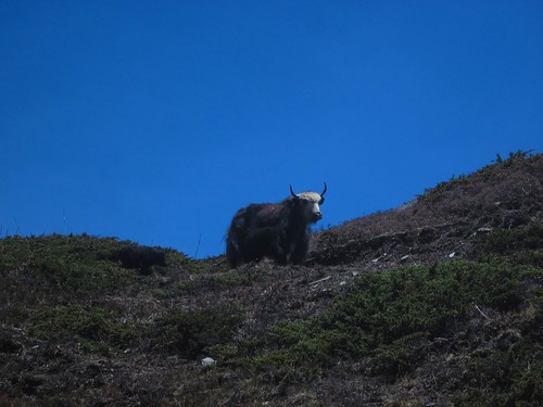
The first herd of yaks came shortly afterwards. A calf approached us nervously while we were resting next to the track, came tentatively closer and then ran towards its mother just over the crest. She rumbled threateningly us when we passed the family; there are plenty of stories of aggressive yaks pushing trekkers off the trails, which made us act as circumspectly as possible. Maybe they'd heard about my yak meat craving. I'd asked three times for a yak burger, or yak curry, and each time I'd been told that it wasn't available. "No dinner here," the yaks' attitude seemed to say.
Later, an eagle came soaring up the valley, only ten metres away, tacking down the valley into the wind and totally disinterested in our presence. We saw several more that day, circling around the crags high above. Occasionally these uplands reminded me of the hills of home, as the alchemy of altitude and latitude made for a similar climate to Scotland or the Pennines, familiar buzzards and swallows and sparrows and cuckoos calling from amongst Scots pines and scrubby bushes. I suppose the yaks could pass for highland cattle at a careless glimpse, but a closer look at the unfamiliar bird species, Bonelli's Eagle especially, reminded me that I wasn't in the UK, and surrounded as I was by some of the world's tallest mountains, I was passing through a landscape unlike nothing I'd seen before.
As well as the flora and fauna, the temperature made me feel more comfortable than the heat of the plains. The sun was bright and intense, but the air was cool. I never felt especially cold, despite travelling very light. My lightweight set-up (I had a pair of trousers, two pairs of socks, two short sleeved tops, a fleece, a rainjacket, gloves, a pair each of arm and leg warmers, a couple of buffs and a sleeping bag liner crammed into a tiny bag along with my diary, maps and toiletries) drew a few comments, but I was amazed in turn by how much some people seemed to think they required, not to mention the number of people who had porters to carry... what? I would have boiled if I'd worn a downjacket, since there was very little standing around, and a sleeping bag was excess weight when every hotel could provide extra blankets. The compass I carried felt a bit unnecessary, and one soldier asked if I was Israeli army, since apparently only the Israeli army carries compasses, but I'd hate to head into the unknown without one. Apart from Zita and Arpi carrying their own food, I didn't get to the bottom of why everyone else had so much more kit. Mind you, their bags were doubtless more comfortable than mine, which is only supposed to be used for carrying light things over small distances and tended to dig into my shoulders, but it was less uncomfortable than I'd feared.

A trio of Czechs and Slovaks at Thorung Phedi were amongst those who made the comments. I asked if they'd felt they'd needed extra climbing practice, as we'd watched them bypass the modern suspension bridge in favour of a rickety wooden affair at the bottom of the steep-sided valley which added a hundred metres or so of extra climbing up a stony trail. We did try waving to them, but they ignored us. Honestly, they'll let anyone on this trail. I bet they didn't have a compass.

Thorung Phedi was starting to feel a little cool, especially out of the sun. As night fell we were inside, supping on pasta and cheese, but not beer at those prices (450 rupees a bottle). More games of Knock-Out Whist with a Mexican and a Lincolnshire lass who said it reminded her of caravanning at Humberston Fitties with her gran. We also had an audience, a mongoose catching moths at the window.

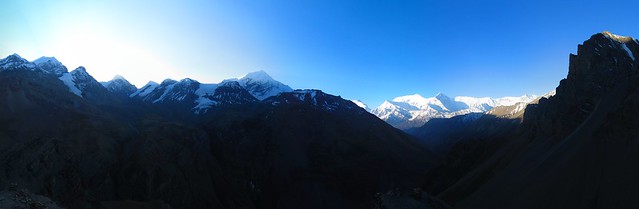
Up at 4.15. This still wasn't as early as others, most of whom we'd caught up before we reached High Camp. I thought it'd be a bit daft to set off up a steep trail in darkness, and I felt we had the right timing, as we caught the sunrise touching Annapurna III behind us as we climbed. It was, however, a tough trail on which I set a careful pace and had to stop regularly to catch my breath. It's only about a kilometre, but the distance is less significant than the 400 metres of ascending. We were at High Camp for a proper breakfast after about an hour, and Thijs talked me into going up the nearby summit. I was pleased that he had, as it offered panoramic views of the nearby peaks and the first rays of dawn creeping over the crags.
I started to experience the first signs of altitude sickness: a growing headache and nausea, but it was easier to go on and over than to go back. Upwards to the pass and above the snowline, into a bare landscape of snow and rocks and ice and a few stubborn tufts of grass. Nothing else grew there, and the only other sign of life was a lone moorland bird, quite like a large curlew. Only the wind and the icy stream moved, and as we approached the pass we left the water behind. Even the regular passage of locals on their way between villages ceased. Nobody comes here by accident, and few do it casually.
Thorung La itself was a blaze of coloured flags and alive with trekkers. This seemed strange, as it was the low season, and Thijs and I had both commented on how few other trekkers we'd seen. We were both pleased about that, and I can't imagine that seeing it under thick snow makes it so much more beautiful that it's worth sharing the route with a few hundred other walkers. The day we crossed the path was as clear and perfect as we could have wished for. There were about twenty other people at the top, resting and taking photos of each other at the famous sign, of which there are probably a million photos out there, but only one has me in it.
When Thijs took the photo he said "Yeah, that's a good expression - smug." As if to prove that pride really does come before a fall, almost my first step on the descent was to miss my footing on a loose stone and twist my knee. Not badly enough that I couldn't walk, thankfully, but I had to find my way very gingerly down the trail, which was a calf-crunching, knee-wrenching, foot-wrecking horror. It was steep, it was stony, then it turned even more steep and stony. The hazy view of the distant peaks behind Mustang remained an unchanging, uninspiring tableau.
Three uncomfortable hours later we finally reached a point where we no longer descending. Those four or five steps uphill to the hotel felt like floating. When we were half an hour from the bottom - and therefore the pass was two and a half hours behind us at a downhill pace - we passed a lunatic going up the other way. He was already taking duck steps and looked as though his shoes were filled with lead. Good luck, mate.
As with many passes, there was a sharp sense of transition between the Manang and Mustang valleys, or at least lower Mustang. We arrived at Muktinath, which is connected to Pokhara by a jeepable road and is a pilgrimage site for Hindus, and it was busy, Indian tourists wandering about in jeeps, a Nepali motorbike gang hanging around the gates, souvenir stalls and hotels and the world's most preposterously expensive internet cafe: 600 rupees an hour. Quite a contrast to remote Manang, and probably a sign of things to come when they complete the road.
I wasn't keen to hang around. I had to get back to Pokhara and then go to retrieve my bike, then on to the British Consulate in Kathmandu to have a word about a problem with my passport.
Walking was going to take another week. Public transport was the fastest option, or public-ish. The jeep for tourists was a couple of hours away and rather expensive, but there was a handy truck heading for Jomsom, and we blagged a lift in the back of it, once the cement had been empties from it. It would have been much better if one of the Nepali cement shovellers hadn't spent the entire journey singing along to his mobile phone. I asked if he was a professional singer, and told him that he could make money out of that voice. I'd have paid him to shut up. With the rough road and lack of suspension, it was the bumpiest journey of my life...up to that point.
Thijs went along to the hospital in Jomsom to ask a doctor about his bowel issues. However, the doctor said it would require a rectal probe, which Thijs wasn't enthusiastic about getting in that hospital, which reminded me of the 1940s-constructed primary school I'd attended. We went off to find a hotel instead, which was easy enough in Jomsom, an even bigger town than Muktinath but with a much more pleasant atmosphere. We stayed at the marvellously-named Dancing Yak, and I finally got myself a yak burger.
Choices, choices. Jomsom has an airport, with daily flights to Pokhara on propeller planes offering beautiful mountain views and an arrival in Pokhara within an hour or two. However, I have an objection to flying, and to paying $94 when there's a cheaper alternative. There was also the slight issue of the plane crash a week and a half previously; fifteen people had died, three are still in hospital, and the wreck of the flight was still embedded in the mountainside, in full view from the airport. It would probably be tasteless to ask if they did fly-pasts.
The alternative began with a bus to Ghasa. Though it didn't feel so, it was the most pleasant part of the journey. OK, we were behind the back axle and felt every bump, the bus was lined with speakers and the music of choice was a special compilation for the journey, The Worst Music in the World, with every country represented. Thijs came over all patriotic when the Venga Boys came on, but my brain had thankfully shut down by then. It was a relief to have to get out and walk when we came to a bridge which wouldn't bear the weight of the bus and passengers (there were other bridges where I would have volunteered to get out), and another crossing without a bridge, where we all forded the river with our possessions and alighted another bus. All of the Nepalis took this as a matter of course, and to us it was all part of the adventure, even when the driver departed from the road and began making up his own route along the monsoon riverbed. Seeing a few other tourists along that dusty valley, I was relieved that I hadn't walked, although sitting at the back of the bus and looking forward as the bus tackled the mountain switchbacks reminded me intensely of the last scenes of the Italian Job, and we all know how that ended.
Ghasa came sooner than I expected, and I'd held off travel sickness for the first leg. There wasn't much of a break before we climbed aboard our second form of transport of the day, the jeep to Beni. Again, we were at the back, and this proved to be the bumpiest, least comfortable journey of my life. I spent the entire journey bouncing up and smacking my arse off the seat, closing my eyes when we went particularly close to the unbarriered edge high above the torrent of the Kali Gandaki River on the wet, rocky road, and trying not to throw up (travel sickness, rather than fear). It would have been more bearable if the damn jeep hadn't broken down for three hours when the drivebelt needed replacing.
When we eventually arrived in Beni, the last bus to Pokhara had long gone, and the taxi drivers were quoting absurd prices for the 45 miles to Pokhara. I was ready to give up and grab a hotel, but while I was waiting for my head to stop spinning and batting off the juvenile beggars, Thijs was asking some of our fellow inmates from the jeep if they were heading to Pokhara.
So we ended up, six of us in an early eighties hatchback: me, Thijs, the driver, a Nepali girl, a Nepali grandmother and a Buddhist nun. The grandmother took the front seat as the biggest of us (though I was trying to angle that for myself), and I still don't know by what contortions the rest of us managed to fit across the back seat. Thijs claimed that he'd been on less comfortable journeys in India, but the position of my face against the window made it difficult for me to frame a response.
There was a huge storm rolling through the mountains around Pokhara. Flashes of lightning came at the rate of three or four a second, and how the rain fell. The roads were inches deep with water as the drains in Pokhara couldn't cope. I still got out of the taxi early, and walked to my guest house to let the blood in my sadly abused legs re-circulate. I collected my kit, took a room, and slept.
Well, I failed to cycle the route, but it's a journey which is better done by foot, or at least by mountain bike, and it was something of a holiday to leave the bike behind for so long, even on the descent from Thorung La. One of the things I had come away seeking was proper mountains, and the glittering peaks of Annapurna satisfied that part of my soul, for now. But like so many other places I've visited, I've left with the urge to go back, to wander the secret valleys of Upper Mustang, roam the high passes of distant Langtang, and I never did go up to Everest Base Camp.
Part of the joy of travelling, however you travel, is to form your own impressions of places you visit, to find places which you'd love to re-visit, and to anticipate the pleasure of seeing places you haven't been able to see. Two months in Nepal simply isn't enough time. I'll be back.
I'd read about people cycling the Annapurna Circuit, and I fancied giving it a try myself, on the same bike with which I'd ridden to Nepal. I knew that the trail would be very rough and rocky in places and I expected that I'd have to carry my bike for about a quarter of the time.
I made minimal changes to the bike. I took off my clipless pedals, fitted some flat pedals and bought some walking shoes.
I could have bought some knobbly tyres, or taken off my mudguards and racks to save weight. I could also have bought a big rucksack to let me carry my kit on my back and fangled a way of strapping my bike to it for the portage sections. I did none of these things.
I suppose the reactions of other people who'd trekked the route should have given me a hint. Non-cyclists were very enthusiastic and said I'd be fine apart from a few places, including the highest and toughest day where I'd have to carry the bike from Thorong Phedi at 4450 metres ASL to Thorong La itself, at 5416 metres ASL. They also told me there was a road a lot of the way round. Cyclists, on the other hand, tended to wince and say things like "travel as light as you can" or, less reassuringly, "I wouldn't".
In the end, my circuit involved six different forms of transport, and may yet include a seventh. But in the end, it was simply such a wonderful place to be, surrounded by jungles and towering cliffs which gave way to vast mountains where eagles swooped and yaks grazed, breathing the crisp air in remote villages which were, in some ways, remarkably unspoilt by tourism and the trappings of modernity, that it hadn't really mattered how I'd got there.
Day 1 -17/05/2012. Pokhara, Damauli, Dumre, Besisahar - 72.36 miles, 11.95 mph average, 37.5 mph max.
Bright was the day and high was my heart when I left Pokhara. I was awake early and after two breakfasts I left Pokhara with the clearest views yet of the white mountains above the lake, Macchapuchra (or, more prosaically, Fishtail for its slightly curved profile) being particularly prominent.
The strike was still ongoing. In the guest house the previous night an Indian couple had been panicking about getting to the airport the next day, to the point where the husband was screaming down the phone at some poor policeman and demanding a police escort through the baying hordes. The airport is about a half hour walk away, with luggage. If I'd have been around I'd have offered to take their luggage to the airport by bike for 1000 rupees while he and his wife walked.
I didn't see any roadblocks on the gentle downhill to Damauli, but the highway was packed with people, especially children, playing football, cricket or skipping games, rolling hoops, or just running about. It was quite charming, except for when the kids started deliberately blocking my path and demanding money, and the less said about the solitary stone-chucker, the better.
At Dumre I turned off the Pokhara-Kathmandu highway, and along the valley of the Marsyangdi river. At this point it was a wide channel surrounded by farmland, though the current was strong and the water was a rich blue, carrying sediment straight off the glaciers which were melting in the early summer heat. I'd be following this river for a long time, and see it change character from the wide farmlands which characterised its banks between Dumre and Besishahar. I had a half hour break beneath the spreading branches of a tree which marked the edge of a fallow field.
No tourists stop along here. They all take a bus to Besishahar. Everyone stared at me in the villages when I stopped for water, an experience which I have never become accustomed to, even in India. Still, I was pleased to be on a bike - even if the buses had been running, the bus journey would have taken six sweaty hours, which is only an hour quicker than my ride from Pokhara.
Day 2 - 18/05/2012. Besishahar, Bhulbhule, Ngadi, Syanje - 15.18 miles, 4.67 mph average, 15.8 mph max
That hotel in Besishahar was weird. The husband spoke good English and his wife didn't, but it was always her who took my food orders, so I got fried chicken without the promised chips instead of roast chicken, then in the morning I got toast instead of porridge. I should have ordered toast and porridge.
After breakfast, second order of the day was to have my card stamped at the TIMS office. There are police checkposts marking the route, to ensure that only tourists who've bought the permits enter, and to ensure that they stay on their route. It costs 3700 rupees for the permits to go around the Annapurna Circuit (there are two bits of paper, ACAP and TIMS: ACAP is the authority issuing permission to enter protected areas of Nepal, and TIMS is the Trekker Information Management System to keep track of tourists for their own safety and to regulate entries into the protected area). At nearly thirty quid, that is expensive, unless compared to the £300 they charge to visit Upper Mustang, a closed and mysterious place which I glimpsed later in the trail.
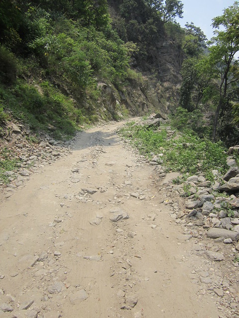
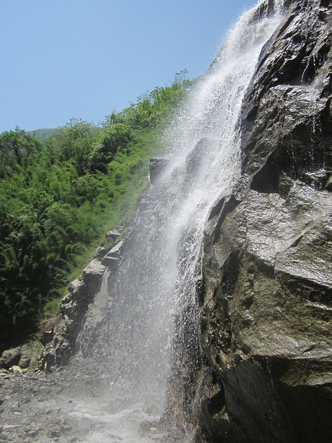
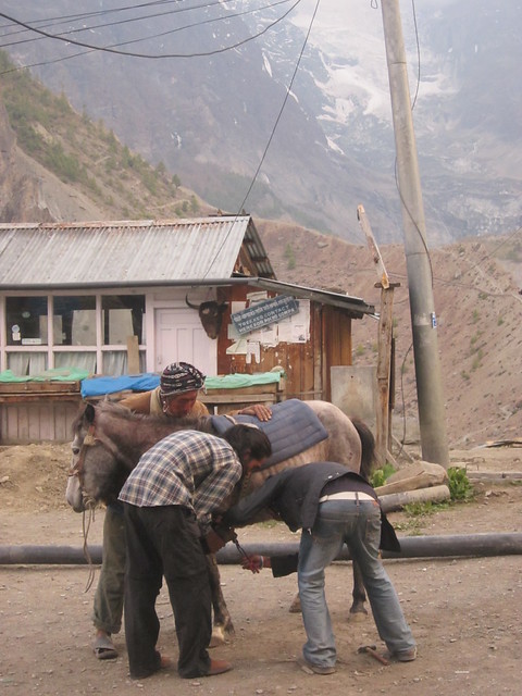
The road was rough. It's just a track blasted out of the bedrock, and there were times I had to push uphill, as I simply couldn't get any purchase on the loose rocks. The bedrock jutted out of the road in many places, and even the occasional jeeps struggled on those sections. I did nip over to the trekking route for a bit after Bhulbhule, and sat for a while next to one of the many waterfalls (in the UK these would each be tourist attractions in their own right with names like the Dragon's Breath, but in the same way that nobody would bother naming the pebbles on a beach, the waterfalls remain nameless), and rode along a gentle grassy track for a bit. I realised my mistake when I had to shoulder my bike for some rocky sections, and I gave serious thought to stopping at 9.30 am.
 |
| the waterfall near Bhulbhule (and my mascot) |
The pushy guy at the hotel where I had a pancake told me that I could cross back to the road at the other end of the village. It did involve lofting my bike up a five foot gap at either end of an unfinished bridge, and pushing up the steep road at the other side. And then falling off. I hit a loose stone on the slight descent and lost my front wheel. A couple of Nepalis dashed up to check I was OK, which I was, except for some scuffs on my right knee and a few bruises. I washed my knee clean in the waterfall and plodded on, perhaps with a little more caution. I hadn't been going quickly anyway, and with the mix of pushing uphill and careful descending, a cheery local was nearly matching my pace on foot.
I was knackered when I stopped, even though it was only 1 o'clock in the afternoon. I felt quite down - I was still in the low jungles, it was still hot, and the roughness of the trail and the road had been getting me down. I had a nap.
My hotel was an arrangement of wooden boards and a large wasp was building a nest against one wall of my room. I didn't bother him and he didn't bother me. There was nothing to do except read and watch the storm which built up in the later afternoon and roared down the gorge, but with my afternoon nap I didn't get to sleep until after one in the morning.
Day 3 - 19/05/2012. From Syanje, Jagat, Chamje - not very far at all.
Are Spaniards naturally pessimistic, or is it just Castillians?
I'd started early and enjoyed the clean air and the way the sunlight gilded the distant peaks. I stopped for a good-but-expensive apple pie which was freshly made while I waited. This gave the herd of donkeys with which I'd been playing leapfrog all morning another opportunity to catch up. Without many roads, most things are still hauled up to Manang District by donkey or porter, which goes some way towards explaining the prices of luxury items such as beer and chocolate. The lines of porters and donkeys give a medieval feel to the remote places, but there was often a modern twist; one porter was carrying an electrical generator on his back, another a television. Another had cages full of chickens.
I arrived in Chamje at about 11 o'clock and decided not to stop. My cycling map/guide was ten years out of date, so it hadn't mentioned the road up the valley, but this was where the road ended, and it said that the next section to Tal was 90% carrying. I shouldered the bike and was about to start descending the steep, rocky track when the Spaniards came and stole my mojo.
I stood aside for them to come up the track; one said "good luck" and the next shook his head. "Where are you going?! 70% of the trail is like that!"
I shrugged, smiled and waited for them to pass.
Then I stopped. They knew what they were talking about, right? Maybe it was impossible.
I let the donkeys overtake me, then returned to the village to catch up with the Spaniards and investigate further.
Turns out, they'd come from the Manaslu trek rather than around Annapurna, so they had only seen the next ten or twelve kilometres of my route. I had a drink and, even though my confidence, already fragile from the amount of pushing so far and the tumble the previous day, was at its lowest, I hoiked the bike back onto my shoulder and told them I was at least going to try. The miserable sod said "you'll remember me when you have to carry your bike back in three hours' time".
I always find walking downhill tougher than uphill, as the muscles are very different to those used going uphill, which are similar to the much-exercised muscles I use when cycling. I was also trying to find a comfortable position for my bike, while keeping a hand free to hold onto rocks and keep my balance.
I walked the bike over the footbridge, which swayed alarmingly under the weight of the troop of donkeys crossing ahead of me. The trail didn't improve at the other side, and with the extra weight on my back my knees were reminding me why I'd given up a lacklustre football career. My shoulder was already bruised from the weight of the bike, I was struggling to lift it onto my back and each time I lowered the bike I came closer to dropping it. I had serious doubts that my knees would take ten more kilometres of that, or even one more. I sat on a rock and finished my juice. Even with reassurances from my guidebook and other trekkers that the route improved, it would be a weary way to Tal. Watching the donkeys wind their way between the rocks, I realised why the wheel wasn't invented in Nepal.
Back to Chamje, then, where I planned to leave my bike and walk the rest of the route. I'd had enough glimpses of the peaks to assure me that I'd enjoy it, and it didn't matter how I got up there; being there was what I wanted, with or without the bike. For the first time since I'd left Darlo, the bike felt like a burden.
An Irish lass came past while I was on my rock. I told her with a wry smile that this wasn't cycling country so I was just going to walk on. She told me that she'd seen me riding up when she was on the bus from Pokhara, and she was impressed with how far I'd come. I always did like the Irish more than the Spanish.
The lovely owner of Tibet Lhasha Hotel was quite happy for me to leave my bike and collect it from her in a week and a half. I spent the rest of the day reading, and writing, and watching the other travellers come and go. I could have started walking that day, but I preferred to mark the end of the cycling with a full stop rather than a comma.
Day 4 - 20/05/2012. Chamje, Tal, Danakyu
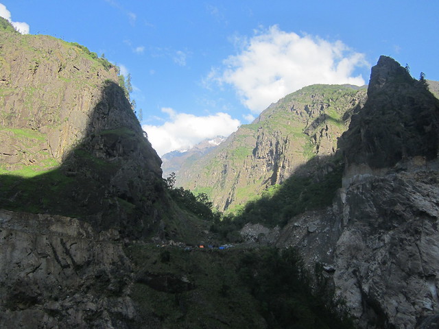
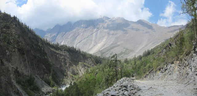
Big landscape today. I was walking up a high, craggy canyon. There were some fabulous views with the river and the jungle in the foreground, rocky outcrops in the middle distance and the peaks around Manaslu murky behind the clouds.
The walk along the valley and the "long hot steep climb" to Tal wasn't as tough as I'd expected. It was certainly easier without the bike, and I was chatting to a couple of Nepali girls who were walking back to their home in Lower Pisang. Typical of Nepalis, they were walking in ordinary clothes and flip flops, quite a contrast to the fully kitted-out tourist trekkers.
We all had to wait after Tal while the new road was being blasted out of the rock. The explosions echoed down the canyon and when we started walking again there was debris all over the trail - not just rubble, but huge lumps of pale rock which had been projected across the river. The new road is about a month from completion, and I commented to the Nepali girls that it would make their lives much easier, as they'd be able to travel home in half a day by jeep or motorbike, instead of having to trudge for two days along a rough trail. I imagine it will also change the nature of the Manang district, and if I ever do return I'll enjoy playing the old lag and telling everybody "Aye, 'tweren't like this back in my day, before they built that road".
I stopped in the early afternoon and spent the afternoon and evening chatting with a Sherpa who was guiding a Korean around the trail and who had some great stories of climbing the summits with groups of, erm, varying abilities. Sonam has been to the summit of seventeen of Nepal's highest peaks, so this must have been really easy for him, especially at the pace his Korean charge was making. I saw Thijs passing by, whom I'd met at breakfast in Chamje, so I waved him into the hotel and tried to get a discount off the room for bringing the owner more trade. The owner wasn't having it.
Day 5 - 21/05/2012. Danakyu, Latamarang, Chame, Upper Pisang
Peakspotting with Thijs. The map I had wasn't detailed enough to follow the trail, and the trail was so easy to follow that Thijs and I boggled at the number of people who had guides. However, the map did help us to identify the peaks which came in and out of view throughout the day. Manaslu (the eighth highest mountain in the world) was reflecting the bright sun back at us from its icy slopes first thing in the morning, and Annapurna II hoved into view as we climbed.
I was disappointed with the naming of the mountains. Come on, Annapurna I, Annapurna II, III and IV? They could at least give them names such as Annapurna Eagle's Lair, or Annapurna-Where-Death-Waits; Annapurna I is reputedly the world's most dangerous mountain, and the tenth highest in the world. Thijs agreed that the features on the trail needed more evocative names, so we started calling sections of trail the Diamond Path for its sparkly mineral deposits, or the Path of Thyme for the abundance of the herb, and Mount Doom for one dramatic, sheer escarpment at a bend in the river. When he gives up his medical studies for a career as a Dark Lord, Thijs is going to build his evil lair at the top of Mount Doom.
 |
| Mount Doom |
Thijs was good company, and as our pace was similar we walked the rest of the trail together. It was a big advantage of walking over cycling, that I had more of an opportunity to walk and chat with other tourists. His conversation did revolve around the state of his bowels, his month-long bout of diarrhoea, and the worsening state of his stools (he's a medical student, and capable of going into painful detail about the subject), but long bike rides with my mate Martin have inured me to this sort of thing.
The other topic of conversation was the increasing expense of food. We thought it was fair enough, for a bottle of mineral water to be seven or eight times the lowland price when it would have been brought up there by porter or donkey, even if we weren't prepared to pay it, but in Yak Kharka a single chapati was 170 rupees. For one chapati! We'd been walking amongst wheat fields less than a mile back, so it wasn't as if the ingredients were terribly exotic. In Pokhara a chapati is fifteen rupees, in the expensive places, so that's more than a 1000% mark-up. Dhal bhat (rice, lentil soup and potato curry), which I'd been eating for 70 rupees in western Nepal, was rising above 400 rupees.
While failing to find the cheapest thing on the menu in Yak Kharka, we met Zita and Arpi, a Hungarian couple who are honeymooning around the world on recumbent bicycles, although they weren't foolhardy enough to attempt the Annapurna Circuit on their steeds.
We walked with them to Upper Pisang and stayed at the Yak and Yeti Hotel, or the Nepali version of Fawlty Towers. An incredibly drunk man invited us in and we agreed rates. Since Thijs and I were eating meals there, we had our room free, but since Zita and Arpi had stoves and their own food they paid for their room, with the understanding that they could cook their own meals. We sat and talked around the wood burner, with Zita and Arpi's pans bubbling on top of it, but the atmosphere was hardly comfortable, as the matriarch of the family insisted on supervising the feeding of fuel into the fire, not letting Thijs put more than a little wood in a time. It's not as though wood is a scarce resource - it's one thing they certainly don't have to have carried in. The drunk son became more drunk, developing a twitch and insisting on talking to us in pidgin German: "Scheisse! Guten tag!" The father turned up and grumped about and truly soured the atmosphere in Basil Fawlty style by telling Zita and Arpi that they couldn't stay if they weren't paying for food. "This is no way to run a business," he told them, and the irony obviously escaped him. Thijs and I said that we'd just go to a different hotel if he wanted to move the goalposts, and since we owed him money this shut him up, even if it didn't mollify him. Later on he came back in and sat watching Indian soaps on the TV, which we'd hoped to use to watch a movie, and threatened to clout his increasingly incoherent son around the lughole. We were waiting for him to start arguing about money again, which he didn't, and in the morning he seemed happy when he had his money, although he did wake us all up by marching up and down the corridor while bawling into his mobile at the top of his voice.
Day 6 - 22/05/2012. Upper Pisang, Lower Pisang, Humde, Mugje, Braga, Manang
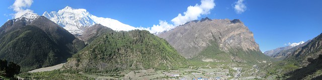 |
| Annapurna II |
The sheer white bulk of Annapurna II to the south greeted us on waking. Zita and Arpi were taking the high trekking route to Manang, but Thijs and I decided to take the low road.
We were past the section marked on the map as "peaceful forest" (other features of interest on the map were "apple orchards" and "fields of marijuana" - we missed the apple trees, but there were acres of marijuana), but the trees seemed no more warlike than previously, as we wound our way through the pines which dominated these upland slopes, and up the broadening valley. The enclosing canyon walls had opened up, high peaks now touched every horizon, and there was space for an airport at the next village, Humde. Not many flights arrive or depart here, but it's an important connection with the world outside, like the occasional helicopters which passed by.
We also met Judy and Merv, a couple of Aussies who were here as part of their retirement to sail around the world. Obviously, Nepal is very landlocked, but the ship they've bought is named the Thorong La, and they felt they had to take a break from fitting out their vessel to come and do the trek. As they were from Sydney and Newcastle, I told them they had to visit north east England, especially Newcastle-upon-Tyne and the Dorman Museum in Middlesbrough, as the Sydney Harbour Bridge was constructed by Dorman Long, and modelled upon the Tyne Bridge. We went on to have a fine discussion about Victorian engineering. It's strange where conversations lead you.
Thijs and I arrived in Manang before 1 o'clock, and stayed at the Marsyangdi Hotel, which was the cheapest we could find, where the food was good, where the restaurant looked out to Annapurna III and Gangapurna, and where this kid came to stand next to us and stare while we were eating. Disturbingly, he only appeared at night.
 |
| prayer wheels in Manang |
Day 6 - 23/05/2012. Acclimatisation day in Manang
A lot of our fellow trekkers took time on this day to go to higher altitudes, to aid acclimatisation higher up. Manang is over 3500 metres, and the pass is 2000 metres higher, so the plan makes sense. A popular trip is up to the nearby monastery to meet the 100 Rupee Necklace Guru, but I couldn't be bothered. A lie-in until seven o'clock and a leisurely breakfast. I hadn't been experiencing any problems with the altitude so far, except for a natural shortness of breath. Things were bound to get more interesting higher up, though.
After a wander round town and to the post office, where they didn't sell postcards, otherwise I'd have sent a couple back - 25 rupees (17 pence) for a postcard with a stamp from the midst of the Himalayas seemed a pretty good deal to me, Thijs was keen to have a closer look at some cave houses which had been carved out of the rock wall at the edge of the valley. It was quite a scramble up, and the bugger took a video of me struggling to keep my footing on the loose scree and gravel. That won't be making the light of day. Going down was much more fun, a matter of sledging and surfing on the debris. I felt as though I'd taken half the hillside down with me, and we speculated that the inhabitants must have had ladders to go home.
On the way back we met Arpi and Zita again, who had taken two days to walk the distance we'd covered in half a day. It's not a race, of course, and they'd spent an extra night at one of the medieval mountainside villages, coincidentally at a hotel owned by the brother-in-law of the Yak and Yeti hotel in Upper Pisang. They said he did a fine impression of His Grumpiness.
As it was Arpi's birthday, we went off to the cinema and spent the evening playing card games which I dredged from my memory. Everyone took to Knock-Out Whist, but Chase the Ace was not so much fun without a little bit of gambling being involved.
That was the evening we hit the rakshi, a rice wine brewed locally, in an old boot by the taste of it. I did most of the drinking; since Thijs refused to take more than a sip and Zita wasn't that keen either, I drank both of theirs. It didn't taste much better even after the third glass, and attempts to mix it with Sprite and Coke weren't entirely successful.
Day 7 - 24/05/2012. Manang, Gunsang, Yak Kharka, Thorung Phedi
This was the first day when things began to feel very remote. We left behind the Marsyangdi River and climbed, firstly alongside the Thorung River, then up the Kone River, which rises in the glaciers to either side of the pass itself.
The lack of oxygen at this altitude started making itself felt. I kept to a steady plod uphill, and called for regular breaks to rest my heavy legs. I had thought of stopping at Ledar (4100 metres and 60% oxygen compared to sea level), rather than ascending a full 1000 metres in a day to Thorung Base Camp, but we were there not long after ten in the morning, and in contrast to other days, the clouds weren't drawing in to cover the peaks. There were clear views in all directions, so I thought "sod it" and carried on.
The first herd of yaks came shortly afterwards. A calf approached us nervously while we were resting next to the track, came tentatively closer and then ran towards its mother just over the crest. She rumbled threateningly us when we passed the family; there are plenty of stories of aggressive yaks pushing trekkers off the trails, which made us act as circumspectly as possible. Maybe they'd heard about my yak meat craving. I'd asked three times for a yak burger, or yak curry, and each time I'd been told that it wasn't available. "No dinner here," the yaks' attitude seemed to say.
Later, an eagle came soaring up the valley, only ten metres away, tacking down the valley into the wind and totally disinterested in our presence. We saw several more that day, circling around the crags high above. Occasionally these uplands reminded me of the hills of home, as the alchemy of altitude and latitude made for a similar climate to Scotland or the Pennines, familiar buzzards and swallows and sparrows and cuckoos calling from amongst Scots pines and scrubby bushes. I suppose the yaks could pass for highland cattle at a careless glimpse, but a closer look at the unfamiliar bird species, Bonelli's Eagle especially, reminded me that I wasn't in the UK, and surrounded as I was by some of the world's tallest mountains, I was passing through a landscape unlike nothing I'd seen before.
As well as the flora and fauna, the temperature made me feel more comfortable than the heat of the plains. The sun was bright and intense, but the air was cool. I never felt especially cold, despite travelling very light. My lightweight set-up (I had a pair of trousers, two pairs of socks, two short sleeved tops, a fleece, a rainjacket, gloves, a pair each of arm and leg warmers, a couple of buffs and a sleeping bag liner crammed into a tiny bag along with my diary, maps and toiletries) drew a few comments, but I was amazed in turn by how much some people seemed to think they required, not to mention the number of people who had porters to carry... what? I would have boiled if I'd worn a downjacket, since there was very little standing around, and a sleeping bag was excess weight when every hotel could provide extra blankets. The compass I carried felt a bit unnecessary, and one soldier asked if I was Israeli army, since apparently only the Israeli army carries compasses, but I'd hate to head into the unknown without one. Apart from Zita and Arpi carrying their own food, I didn't get to the bottom of why everyone else had so much more kit. Mind you, their bags were doubtless more comfortable than mine, which is only supposed to be used for carrying light things over small distances and tended to dig into my shoulders, but it was less uncomfortable than I'd feared.
A trio of Czechs and Slovaks at Thorung Phedi were amongst those who made the comments. I asked if they'd felt they'd needed extra climbing practice, as we'd watched them bypass the modern suspension bridge in favour of a rickety wooden affair at the bottom of the steep-sided valley which added a hundred metres or so of extra climbing up a stony trail. We did try waving to them, but they ignored us. Honestly, they'll let anyone on this trail. I bet they didn't have a compass.
Thorung Phedi was starting to feel a little cool, especially out of the sun. As night fell we were inside, supping on pasta and cheese, but not beer at those prices (450 rupees a bottle). More games of Knock-Out Whist with a Mexican and a Lincolnshire lass who said it reminded her of caravanning at Humberston Fitties with her gran. We also had an audience, a mongoose catching moths at the window.
Day 8 - 25/05/2012. Thorung Phedi, High Camp, Thorung La, Muktinath, Jomsom
 |
| the steep path to High Camp |
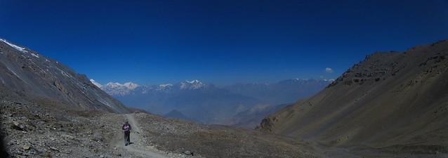
Up at 4.15. This still wasn't as early as others, most of whom we'd caught up before we reached High Camp. I thought it'd be a bit daft to set off up a steep trail in darkness, and I felt we had the right timing, as we caught the sunrise touching Annapurna III behind us as we climbed. It was, however, a tough trail on which I set a careful pace and had to stop regularly to catch my breath. It's only about a kilometre, but the distance is less significant than the 400 metres of ascending. We were at High Camp for a proper breakfast after about an hour, and Thijs talked me into going up the nearby summit. I was pleased that he had, as it offered panoramic views of the nearby peaks and the first rays of dawn creeping over the crags.
I started to experience the first signs of altitude sickness: a growing headache and nausea, but it was easier to go on and over than to go back. Upwards to the pass and above the snowline, into a bare landscape of snow and rocks and ice and a few stubborn tufts of grass. Nothing else grew there, and the only other sign of life was a lone moorland bird, quite like a large curlew. Only the wind and the icy stream moved, and as we approached the pass we left the water behind. Even the regular passage of locals on their way between villages ceased. Nobody comes here by accident, and few do it casually.
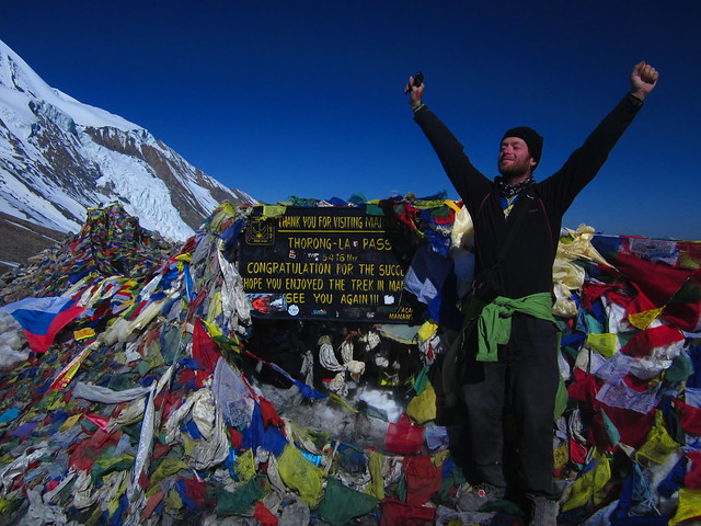
Thorung La itself was a blaze of coloured flags and alive with trekkers. This seemed strange, as it was the low season, and Thijs and I had both commented on how few other trekkers we'd seen. We were both pleased about that, and I can't imagine that seeing it under thick snow makes it so much more beautiful that it's worth sharing the route with a few hundred other walkers. The day we crossed the path was as clear and perfect as we could have wished for. There were about twenty other people at the top, resting and taking photos of each other at the famous sign, of which there are probably a million photos out there, but only one has me in it.
When Thijs took the photo he said "Yeah, that's a good expression - smug." As if to prove that pride really does come before a fall, almost my first step on the descent was to miss my footing on a loose stone and twist my knee. Not badly enough that I couldn't walk, thankfully, but I had to find my way very gingerly down the trail, which was a calf-crunching, knee-wrenching, foot-wrecking horror. It was steep, it was stony, then it turned even more steep and stony. The hazy view of the distant peaks behind Mustang remained an unchanging, uninspiring tableau.
Three uncomfortable hours later we finally reached a point where we no longer descending. Those four or five steps uphill to the hotel felt like floating. When we were half an hour from the bottom - and therefore the pass was two and a half hours behind us at a downhill pace - we passed a lunatic going up the other way. He was already taking duck steps and looked as though his shoes were filled with lead. Good luck, mate.
As with many passes, there was a sharp sense of transition between the Manang and Mustang valleys, or at least lower Mustang. We arrived at Muktinath, which is connected to Pokhara by a jeepable road and is a pilgrimage site for Hindus, and it was busy, Indian tourists wandering about in jeeps, a Nepali motorbike gang hanging around the gates, souvenir stalls and hotels and the world's most preposterously expensive internet cafe: 600 rupees an hour. Quite a contrast to remote Manang, and probably a sign of things to come when they complete the road.
I wasn't keen to hang around. I had to get back to Pokhara and then go to retrieve my bike, then on to the British Consulate in Kathmandu to have a word about a problem with my passport.
Walking was going to take another week. Public transport was the fastest option, or public-ish. The jeep for tourists was a couple of hours away and rather expensive, but there was a handy truck heading for Jomsom, and we blagged a lift in the back of it, once the cement had been empties from it. It would have been much better if one of the Nepali cement shovellers hadn't spent the entire journey singing along to his mobile phone. I asked if he was a professional singer, and told him that he could make money out of that voice. I'd have paid him to shut up. With the rough road and lack of suspension, it was the bumpiest journey of my life...up to that point.
Thijs went along to the hospital in Jomsom to ask a doctor about his bowel issues. However, the doctor said it would require a rectal probe, which Thijs wasn't enthusiastic about getting in that hospital, which reminded me of the 1940s-constructed primary school I'd attended. We went off to find a hotel instead, which was easy enough in Jomsom, an even bigger town than Muktinath but with a much more pleasant atmosphere. We stayed at the marvellously-named Dancing Yak, and I finally got myself a yak burger.
Day 9 - 26/05/2012. Jomsom, Ghasa, Beni, Pokhara.
Choices, choices. Jomsom has an airport, with daily flights to Pokhara on propeller planes offering beautiful mountain views and an arrival in Pokhara within an hour or two. However, I have an objection to flying, and to paying $94 when there's a cheaper alternative. There was also the slight issue of the plane crash a week and a half previously; fifteen people had died, three are still in hospital, and the wreck of the flight was still embedded in the mountainside, in full view from the airport. It would probably be tasteless to ask if they did fly-pasts.
The alternative began with a bus to Ghasa. Though it didn't feel so, it was the most pleasant part of the journey. OK, we were behind the back axle and felt every bump, the bus was lined with speakers and the music of choice was a special compilation for the journey, The Worst Music in the World, with every country represented. Thijs came over all patriotic when the Venga Boys came on, but my brain had thankfully shut down by then. It was a relief to have to get out and walk when we came to a bridge which wouldn't bear the weight of the bus and passengers (there were other bridges where I would have volunteered to get out), and another crossing without a bridge, where we all forded the river with our possessions and alighted another bus. All of the Nepalis took this as a matter of course, and to us it was all part of the adventure, even when the driver departed from the road and began making up his own route along the monsoon riverbed. Seeing a few other tourists along that dusty valley, I was relieved that I hadn't walked, although sitting at the back of the bus and looking forward as the bus tackled the mountain switchbacks reminded me intensely of the last scenes of the Italian Job, and we all know how that ended.
Ghasa came sooner than I expected, and I'd held off travel sickness for the first leg. There wasn't much of a break before we climbed aboard our second form of transport of the day, the jeep to Beni. Again, we were at the back, and this proved to be the bumpiest, least comfortable journey of my life. I spent the entire journey bouncing up and smacking my arse off the seat, closing my eyes when we went particularly close to the unbarriered edge high above the torrent of the Kali Gandaki River on the wet, rocky road, and trying not to throw up (travel sickness, rather than fear). It would have been more bearable if the damn jeep hadn't broken down for three hours when the drivebelt needed replacing.
 |
| got a drivebelt up there, mate? |
When we eventually arrived in Beni, the last bus to Pokhara had long gone, and the taxi drivers were quoting absurd prices for the 45 miles to Pokhara. I was ready to give up and grab a hotel, but while I was waiting for my head to stop spinning and batting off the juvenile beggars, Thijs was asking some of our fellow inmates from the jeep if they were heading to Pokhara.
So we ended up, six of us in an early eighties hatchback: me, Thijs, the driver, a Nepali girl, a Nepali grandmother and a Buddhist nun. The grandmother took the front seat as the biggest of us (though I was trying to angle that for myself), and I still don't know by what contortions the rest of us managed to fit across the back seat. Thijs claimed that he'd been on less comfortable journeys in India, but the position of my face against the window made it difficult for me to frame a response.
There was a huge storm rolling through the mountains around Pokhara. Flashes of lightning came at the rate of three or four a second, and how the rain fell. The roads were inches deep with water as the drains in Pokhara couldn't cope. I still got out of the taxi early, and walked to my guest house to let the blood in my sadly abused legs re-circulate. I collected my kit, took a room, and slept.
After
Well, I failed to cycle the route, but it's a journey which is better done by foot, or at least by mountain bike, and it was something of a holiday to leave the bike behind for so long, even on the descent from Thorung La. One of the things I had come away seeking was proper mountains, and the glittering peaks of Annapurna satisfied that part of my soul, for now. But like so many other places I've visited, I've left with the urge to go back, to wander the secret valleys of Upper Mustang, roam the high passes of distant Langtang, and I never did go up to Everest Base Camp.
Part of the joy of travelling, however you travel, is to form your own impressions of places you visit, to find places which you'd love to re-visit, and to anticipate the pleasure of seeing places you haven't been able to see. Two months in Nepal simply isn't enough time. I'll be back.

ReplyDeleteIt is very easy to for you to contact with us. We open 24/7 to make your appointment and help you all the way. We have extremely impressive escorts are available for dinner, date and party so don't be nervous about communicate with us when mood hits you.Best Escort Services in Shimla with hot body. Book Call Girls tonight in Shimla. Book Hotel and call us. Private hot girl massage in Shimlaescort services in shimla